The berber landscapes of Matmata and Tataouine's region
(Southeast Tunisia)
Throughout history south-eastern Tunisia has been Maghreb’s gateway to the East as well as a way of passage to the south of the Sahara and Sudan. This area is morphologically featured by the plateau of Dahar whose steep margin, oriented north-south, swoops on the Jeffara plain that separates the Jebel from the Mediterranean Sea. The plateau’s margin, known as Jebel, is crossed east-west by valleys, gorges and watersheds of ancient water courses, while in the basins and valleys, now permanently dry, the addition of fine sand carried by wind from Sahara and the salt lakes northern region, gave rise to pinkish and reddish soils on which civilizations have developed that have shaped the agricultural landscape.
In the south east Tunisia, characterized by an arid climate, rainfall does not exceed 50-200 mm per year, moreover there aren’t any significant water sources. People have struggled for centuries against water shortage, by building wells where possible, but mainly through an ingenious hydraulic planning system located in the valleys and ravines, where impetuous and uncontrollable torrential waters gather every rare time it rains on these desert lands, during the rainy season.
The system is based on the barrage of valleys and ravines through serial batteries of small earth embankments (jessour) with surface spillways, that are built across the canyons’width and beyond their outlet on the plain, in order to dampen the speed of outflowing rainwater and store it together with the soil that they had violently ripped from the slopes.
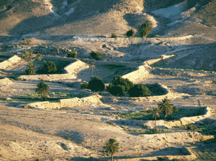
Jessour landscape
These systems have a great impact in shaping the landscape and are able to help store the water, soil and to limit erosion. Water retention intensifies infiltration and increases soil moisture throughout the year, countering the evapotranspiration‘s effects. Sediments retention progressively enriches the soil with mineral and organic intakes.
As a result, jessour make possible the cultivation of cereals and fodder but olive trees, figs trees and date palms can thrive as well. Thanks to the jessour, The olive tree was taken out of climate bounds, with exceptional yields, also thanks to skilful farming techniques.
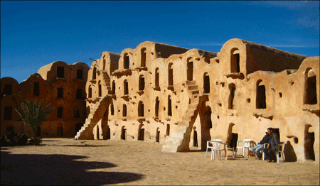
a Ksar example
South east Tunisian landscape is also dotted with particular foodstuffs storage structures called ksar (sing: ksour) that, besides representing real icons of these landscapes, have strongly influenced the villages shape and organization, some ksour are real rural culture monuments today admired by tourists.
These are sometimes considerably heigh buildings (up to and beyond 10 m high), their facades are featured by one or more superimposed orders of openings, each one leading to small rooms.
Drought led people to store into ksar food reserves to face a succession of dry vintages. Grits could stay in good condition for up to 7 years. It was an ideal system for the semi-nomadic Berber shepherds’ life. Morover ksar served as defense fortresses to prevent any raid attempt by external attackers. Up to half of the twentieth century, many ksar were still in activity. The oldest ones, perched on top of hill settlements, are even dated back to the eleventh century.
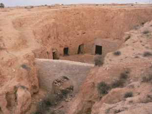
Troglodyte houses of Matmata
Another important feature of this bicultural landscape is represented by the cave dwellings, obtained from the excavation of the rock, sand and clay terrain’s layers of Jebel’s valleys and basins. The determining success factor of these home types was the protection from dry weather and strong temperature changes; with the same technique, oil mills were built. The natural environment integration of these architectural structures is amazing, they give a visual impression of a perfect symbiosis with the surrounding environment. Today, few are the troglodyte houses still inhabited, most are ruined and a small part is used for tourism purposes.