![]() ITALIAN VERSION
ITALIAN VERSION
![]() CONTACT
CONTACT
![]() ITALIAN VERSION
ITALIAN VERSION
![]() CONTACT
CONTACT

For the purpose of identifying PBC areas, AGER has developed a territorial analysis method. It’s finalized to highlight, measure and map the clustering of a number of tangible and intangible-cultural landscape elements and the existence of a network of relationships among each other.
The fundamental characteristic of a PBC is in fact the complex, often recursive, web of relationships among its elements: the shape of the landscape is related to agricultural work, which is in turn influenced by economic and social factors and by the availability of natural resources, all this is reflected on traditional costumes and on what of the area’s natural heritage has to date been preserved, and so on. We can “glimpse” the landscape in each of the thematic areas taken singly, but the final vision that interests us, and that we call bio-cultural landscape, emerges from the ability to capture the interrelationship between these diverse elements; these elements become inseparable from their links with other related elements and in this partnership they take on the final character of bio-cultural landscape indicators.
A remarkable peculiarity of this work is therefore the attempt to bind and treat together data belonging to heterogeneous thematic areas, which are often treated in parallel, without mutual dialogue.
It 'clear that this kind of study approach, in order to be implemented, requires multi-disciplinary skills, ranging from nature conservation to agriculture, anthropology, architecture etc..
this requirement can be met by the presence of a Group Work consisting of experts from various disciplines. This presence, as well as a work mode, based on a synergic dialogue between the experts, is a fundamental and indispensable part of the PBC identification methodological process.
The territory exploration is conducted in order to cover an entire knowledge spectrum: typically, it should be resolved with the following areas of investigation:
floristic field - where the object is represented by plant study area’s species of flora; essentialy the research is focused on that elements of the local flora, beeing of primary bioecological interest and/or having a peculiar role in the connotation of the landscape, in the historical memory and in the rural /cultural traditions belonging to the local context;
faunistic field - the object of which is represented by the indigenous animal species whose presence or persistence can be considered an index of bio-cultural value;
ecosystemic field - whose object is represented by the semi-natural ecosystem units inside the investigated area. Residual ecosystems and micro-areas, that retain a significant degree of naturalness, are included, even in view of their role as natural bioregional emergencies, strongly characterizing the landscape balance;
biogenetic field - where the object is represented by plants and animals breeds and varieties that are endemic species from a genetic point of view. Many local cultivars are known for their centuries-old residence and their genetic origin has been detected during previous studies;
architectural field – whose object is represented by the types of local traditional rural architecture;
ethno - anthropological field – whose object is represented by the rural community’s social, economic, cultural traits, that have greatly helped in building the territory’s deep character, in its specific natural context. The most important role is played by the peasant culture that for millennia has permeated and shaped rural landscapes;
agronomic field - the object of which is represented by agricultural crops and related traditional agricultural techniques. This thematic field can be considered as an extension of the ethno-anthropological field, with a more explicit reference to agronomic techniques as manual skills and as a shaping landscape driving force;
landscape forms field - whose object is represented by the signs and perceptual components resulting from the overlap of natural structures and human activity manifestations..
PBC elements selection criteria
Each field’s survey leads to identify a variety of items for each subject area, but not all of them contribute to form the bio-cultural landscape: indeed, a selection process needs to be performed, based on the criteria below listed:
PERMANENCE. The Items of interest to PBC have characters of permanence, that means that they have survived to recent socio-economic, tecnological and agronomic upheavals.
GEO-REFERABILITY The Items of interest to the PBC leave at least a geo-referable imprint on the landscape, that means that their physical/geographic location can be established with sufficient accuracy.
TYPICALNESS'. The Items of interest to the PBC, are closely related to the geographical area under consideration.
CORRELATION. The Items of interest to the PBC are related to at least one or more elements of other thematic fields, such relationships are clearly observable and may be derived from:
- literature;
- local witnesses;
- direct observations.
Within this grid of general criteria, each field may consider further ones, more specific and restrictive, depending on the specific features of the landscape studied.
Mapping of the bio-cultural landscape
One of the most interesting issues in this methodology is the identification of PBC on a map. The PBC is defined by the presence and clustering of a set of interrelated elements, therefore, a way of representation that could quantify either the densification or the existence of relationships between the elements has been developed.
The first step is obviously the territory surveying through areo-photogrammetry and subsequent field inspections. Next you need to digitize all the identified items, using GIS (Geographycal Information System).
The result of the cartographic restitution and of the GIS digitization, is the overlapping of different vector format layers, showing the pointlike, linear and areal identified elements. Each layer corresponds to a different thematic field.
Once the geo-referring process has come to the end, A spatial data elaboration needs to be undertaken, in order to achieve a mapping of the elements clustering degree and of the amount of links generated by the whole elements.
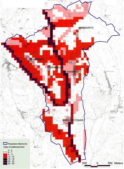
The data represented in the various layers in a vectorial format, are then converted to raster format, using the appropriate pixel size according to the scale of analysis and obtaining a precise vertical overlap of the cells derived from each information level.
The raster conversion is also needed to implement a spatial analysis model that can release, in an output information level, the exploration and arithmetic calculation result of the values in a vertical sequence of stacked layers (overlay arithmetic) .
This processing can be done by applying GIS spatial analysis tools to the grids resulting from the conversion of various vector layers, which allow to precisely perform statistical analysis on multiple overlapped raster formats data sets and allow in particular to produce a raster output that shows, for each pixel, a result of the calculation performed between the corresponding pixels in the different overlapped raster layers used.
An example result of the biocultural landscape mapping is shown in figure up on the left